Roubidoux Spring

rubedu

 1960’s era picture of Roubidoux Spring courtesy of Jo Schaper

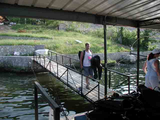
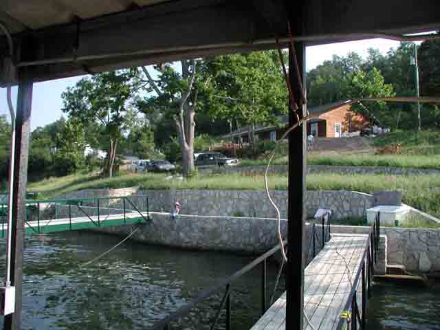
Location: Inside Laughlin Park on the south side of Waynesville, Mo

SIZE: Ranked as the 16th largest spring in the state with an average discharge of 37 million gallons of water a day.  View the stream gauge here.

OWNERS: Owned and maintained by the city of Waynesville, the spring is a certified site on the National Park Service National Historic Trail as an encampment on the Trail of Tears.

DIVING HISTORY:

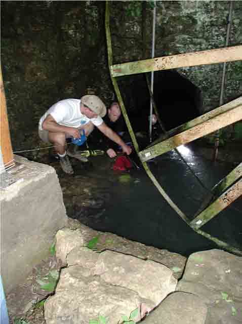
1969 -Don Rimbach with the help of John Viper cleared the spring opening and were the first known divers to enter the spring. They explored and sketched the tunnel back to the “Pit” area, which we now call the first drop-off. Don had a chance to buy the spring from a man named Shindler in 1974 for $2,000. At the time funds weren’t available.

The Pulaski County website has some more interesting information on early exploration efforts exploring the spring in the 1970’s here.

1977 -Roger Miller heard about Roubidoux spring from reading a note in an NSS newsletter, which had Don Rimbach’s phone number. After contacting Don to get the location of the spring, Rodger and Frank Fogerty explored Roubidoux in the 1970′s and mapped the spring back to approximately 1,400′ or the start of the “Big Room”. On one of their survey dives they got turned around while relocating the line and went the wrong way (hence the name “Which Way Tunnel”). You can see their map here.

1980’s – Dave Porter and Rodger Gliedt explored Roubidoux past the Big Room using scooters. Along with Frank Howard they mapped the upper tunnel to the first drop and also installed the first “STOP” sign.

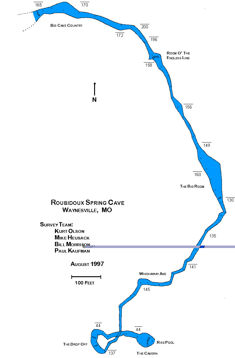
1990’s – Kurt Olsen, Mike Husack, Dave Porter, Doug Chappell and others conducted exploration dives in Roubidoux in the 90’s. Most of these dives were on air with O2 for deco. The most publicized dive being a dive team of Kurt Olsen and Robert Laird in August of 1996 in which they discovered a large room past the third drop-off. Olsen and Husack with the help of Bill Morrison and Paul Kaufman surveyed and created a map of Roubidoux out past 2,500’. You can view their map here.

1997 – Jason Weisacosky and Tom O’Connor start exploring and surveying Roubidoux from the end of the Olsen/Laird line.

1998 – Weisacosky and O’Connor officially formed the OCDA and continued exploration past the third large room named “Lithuania”.

1999 – OCDA team members decide to start surveying the newly explored sections of Roubidoux.

2000 – OCDA members replace 700’ of damaged exploration line from the 2,000’ penetration area to aid in ongoing exploration and surveying operations.

2001 – The OCDA decided to make the on going work to map Roubidoux an official project, and present a finished copy of the map to the local authorities in appreciation of past and continued access. It is also decided to make the map publicly available to promote awareness and safety to divers using the site. Exploration continued with the greatest emphasis directed towards surveying and mapping the already explored parts of the spring.

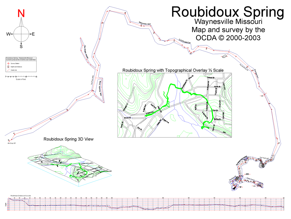
2002 – The OCDA explored Roubidoux spring to a total distance of over 5,800’ at depths up to 265′. Survey data was gathered on the newly explored sections along with two side tunnels and were compiled onto a map. Since this point in time conditions have never really stabilized long enough for visibility to return to normal. Water clarity has started going downhill and may be associated with new construction going on upstream in the spring’s recharge area. At this time dives were in the 6-7 hour range on open circuit using 4-6 stages. Heater shirts became a requirement. The 2002 map can be viewed here.

2007 – The OCDA completes new habitat construction in the cavern zone in preparation for renewed exploration and survey of the far reaches of the system. The old habitat design was outdated and having reached the end of it’s useful life was removed from the system.

2011 – With dry weather conditions in October, visibility improves to 25 feet and the OCDA begins preliminary work to extend the survey in Roubidoux Spring, including repairing the main line and gathering the last bit of survey data from the line placed by the team in 2002. 100′ of new line is installed on the last dive of the year.

2012 – A hundred-year drought in the Ozarks finally allows conditions to improve enough to give the OCDA a chance to explore Roubidoux spring after a ten year hiatus. Visibility improved up to 30′ and flow was very low. The team makes project dives to set up and explore an addition 2,500′ of cave passage. Total explored distance is now 8,300′, of which 7,200′ of the tunnel is surveyed. The habitat is well-used, and 10 hour dive times are the new norm.

2014 – Roubidoux Spring bounds onward with OCDA team diving:  by Jennifer Idol

The Ozark Cave Diving Alliance (OCDA) focuses on not just doing things right, but also on doing the right things. This is never more evident than in our extraordinary accomplishments in 2014, marked by significant exploration progress in Waynesville, Missouri at Roubidoux Spring. As we gathered for our final dive 2014 briefing on December 6, we were keenly aware of the possibilities in Roubidoux. This day would either build on the enormous achievements done during the past three months, or it would be an opportunity to remove the safeties and end the team’s exploration diving in Roubidoux for the season. The exploration divers, Dirk Bennett and Ben Perkins were also keenly aware of the significance of this dive, whether successful for a push or an enormous clean up dive. The OCDA has been regularly completing dives over 10 hours in duration during the past three years. Recently, dives have extended past 15 hours, with exploration divers reaching full saturation levels. Dirk and Ben now wore the seriousness of such lengthy dives on their faces as they briefed the team for the day’s plan. Considerations such as emergent gear failures, oxygen toxicity, hypothermia, fatigue, and dehydration are amply covered in the briefing. A lean crew of nine divers was on site for the last day, so everyone’s participation was essential to make the dives a success.

With a balmy 31º surface temperature at 6:30 am, we divided into two support shifts. The morning shift would dive until 3 pm and then trade with the afternoon shift for surface duties. As Surface Manager, Christa Runkle tracked Ben and Dirk’s dive progress and coordinated timing for the support dives that set up initial preparation for the exploration dive and managed the decompression and extraction process. Although Ben Perkins, Dirk Bennett, Kevin Runkle, and Christa Runkle dove the previous day to verify conditions and to set more than 22 cylinders, additional equipment needed to be put in place. Eight safety cylinders had also been set earlier in the season throughout the system. Today, 6 diver propulsion vehicles, additional batteries for heating thermal underwear, food, water, snacks, timers, and a large slate for writing decompression time all needed to be set. By 9 am, Ben and Dirk started in water safety checks and prepared to begin their dive. Twenty minutes later, they were powering through the cave on their first scooter and headed to the end of the line at approximately 10,080’, set only five weeks earlier.

In August 2014, the end of the line was waiting for us at 8,300’. By December, our team reached over 10,030’ and surveyed all the line. The achievements made from July to December in 2014 are significant, considering that the OCDA last pushed the line in 2012 to 8,300’ from its last end of line distance of 5,300’ in 2002. Team members spend enormous amounts of time and resources to achieve goals such as gathering scientific data, surveys, and samples that will be useful for years to come. 24 team members coordinate regionally to help accomplish and document large and complicated dive projects. Steve Gridley, the Team Director, leads with wisdom and insight reminding us that the diver is our most important piece of equipment from which all other equipment is managed. We build our skills throughout the year so that when the spring visibility and flow is manageable, we’re ready to perform. This last push dive in 2014 is no exception to the accumulation of team skill and operations. Conditions held at Roubidoux with 15’-20’ visibility and 55º water temperatures. Flow was increasing throughout the day due to Friday rain, but was manageable. This proved helpful for Ben and Dirk as they exited with the flow for what proved to be a 15 hour 8 minute dive. As support divers, we plan and prepare for the arrival of our exploration divers, but do not know what they experience during their dive until they return to their first decompression stop. We knew that the dive was looking hopeful when they had not arrived by their first dive time at our initial meet and greet. When Chris Hill met Ben and Dirk at the 100’ decompression stop to check on them and to take excess gear, Ben promptly handed off an empty reel that had contained 1,200’ of line, followed by a fist pump and cheering through the regulator. This was a sure sign that line had been laid. After calculating some quick math, we could guess where the end of the line lay, but upon Ben and Dirk reaching the habitat for out of water decompression, we learned that they also managed to survey the line on their exit. Navigating the cave on scooters at the end of a long dive while operating survey equipment is very challenging. Roubidoux Spring has line set and surveyed to an astounding distance of 11,256’ with depths up to 270’. Ben and Dirk emerged at 12:30 am to an eager support team. By 1:30 am, we were sitting together at Denny’s, tired and cold, but honored to be a part of the history of Roubidoux Spring. With improved conditions and some real long weekends the system has now been pushed out to 11,528′ at a relatively modest depth of 145′.

The new extended Roubidoux Spring map is available here.

NOTES: Roubidoux Spring is open to certified cavern/cave divers who are required to check in and present their cave/cavern certification card to the officials in the 911 Emergency Center prior to diving. The center is located adjacent to the Fire Station on top of the hill off Highway 66 just east of downtown. There is no diving fee or permit required, but be sure to sign out after diving.  Water conditions vary greatly with local rainfall and can change day to day. Be familiar with and consult the stream gauge before driving a long distance. As with all springs in the Ozark Region, the best time of the year to dive the springs is late summer and fall seasons when the weather is normally dry. 

Porter Mill

OLYMPUS DIGITAL CAMERA
LOCATION:
Within the Lake of the Ozarks. Close to lake mile marker 38 by a local boat dock.

SIZE: Too small to be ranked.

OWNERS: Privately owned by Dave Dodson who was interested in discovering the location of the spring and then documenting any further exploration.DIVING HISTORY: In April of 2000 the OCDA was contacted by Mr. Dodson with a request to locate and explore a spring that was said to exist in the Lake of the Ozarks. The team responded within the month and began to search for the spring. However, conditions were very hindering as visibility was only one foot, water temperature was 50F, and a significant amount of trash and brush had accumulated in the area. These conditions can be hazardous to both new and trained divers, and in order to decrease the risk of any accidents the team employed standard safety diving search procedures. This consists of a diver being tethered to the surface (line tender), a fully rigged/ready on-line safety diver, and a surface manager to keep track of dive time. Bottom time for each search was limited to 15 minutes. The spring was finally located at 55’ alongside the bluff near the boat dock, but over 70 years of trash had to be cleared from the opening. After this was done it was determined that the spring opening consisted of a height at 3 to 10 inches, a width of 10 feet, and an entry angle of 45 degrees. Water at the spring opening was noticeably warmer than the lake, and visibility expanded to 20’ from inside. Further diving was conducted, and videography was obtained for Mr. Dodson. However, due to the restrictive nature of the opening further exploration has been suspended.

OLYMPUS DIGITAL CAMERAOLYMPUS DIGITAL CAMERAOLYMPUS DIGITAL CAMERA

Hodgson’s Mill

hodgkins-32LOCATION:  On Missouri Route 181 at Bryant Creek in the South-Central region of the state.

SIZE:  Ranked the 15th largest spring in the state with an average discharge of 23.5 million gallons of groundwater per day.

OWNERS:  Private property of Hank Macler and his wife, Jean.  The Macler’s have benevolently restored the site for public enjoyment

DIVING HISTORY: Hodgson’s Mill was constructed in 1897 to grind flour from wheat and corn.  The OCDA was contacted by Mr. Macler in July 2002 with a request that the team assist in exploring the spring conduit.  The objective was the explore the system and collect information that would promote preservation in future management and development decisions of the site.

Within that month divers were on-site.  First attempts to explore the spring were hindered by high flow and small conduit size.  An access point was eventually discovered beneath the mill, although it was so small that divers were forced to modify their gear configuration using sidemount procedures.  Upon passing this initial restriction it was determined that the passage was too small to continue exploration–the conduit had developed into a vertical slot in dolomite measuring approximately six inches in width.  A second access point from within a small dry cave was attempted later, but this also proved non-navigable.

After a full day of work, diving operations were halted and project diving at this site has thus been suspended. Despite not having much of an underwater system the team enjoyed the support and company of Hank and Jean Macler.  It was an opportunity to support the preservation of this historic and natural landmark, and were recommend this as a site worth visiting for everyone.

Maramec Spring


LOCATION:
Approximately 8 miles south of St. James in Phelps County, Missouri. The spring issues from within Maramec Spring Park.

SIZE: Ranked the 5th largest spring in the state with an average discharge of 99 million gallons of water per day.  

OWNERS: Privately owned by The James Foundation (http://maramecspringpark.com/) and access to diving is restricted by research permit only.


DIVING HISTORY:

1996: Divers from the St. Louis Underwater Recovery Team entered the spring.

1978: Pioneer cave divers Roger Miller and Frank Fogarty began exploration at this site in 1978.They explored and mapped the spring conduit out to 1,725′ and found the maximum depth at 195′. This legendary team had no support team and used mixed gases to accomplish their saturation exploration dives.

1995: The dive team of Jason Weisacosky and Charles Merrell begin to dive the system.

1997: The Ozark Cave Diving Alliance comes into being. Flow and visibility is extremely variable within Maramec Spring, and because of higher flow, the OCDA decided to incorporate the use of underwater scooters for future exploratory dives. Spring temperatures average in the low 50’s, which are perfect for the trout hatchery, but rather chilling for long dives. Most springs are on average ten degrees warmer. The group continued their work from late 1996 to cover several thousand feet of passage, while also providing quality video, photographs, surveys, and a map of the system for the park.

1999: The OCDA matures and work continues with a habitat installed to help combat the 50 degree water temp during the long decompression times experienced due to system depths. The spring conduit has now been surveyed and mapped out to 3,006′.

To date the spring has been explored out to 3,800 ft in length and to a depth of 280 ft. Much of the information on this park, like the seven minute video entitled “The Hidden World Beneath Maramec Spring Park,” is on display inside the Maramec Spring Park Museum.

NOTES: Some species of cave fauna were identified here in 1981 after a liquid fertilizer pipeline rupture in the spring’s recharge area drove them out into the spring run due to low oxygen levels.


Alley Spring

LOCATION: 6 miles west of Eminence in Shannon County, Missouri on Route 106. 

SIZE:  Ranked the 7th largest spring in the state with an average discharge of 84 million gallons of groundwater per day.

OWNERS: Operated by the National Park Service, and included in the Ozark National Scenic Riverways National Park since 1969. Diving is by permit only. 

DIVING HISTORY: In 2001 the United States Geological Survey requested the assistance of the OCDA to obtain scientific data from within Alley Spring. To date the team has surveyed/mapped several thousand feet of passage, collected rock and sediment samples, and taken video and photographs within the system. Just under 3000′ of the system has been surveyed with an average depth of 155′. Outbound divers encounter a rapid flyover point in the system where divers come out of 150′ and rapidly  cross the Kentucky Peaks area at 60′ before descending again to 145′. This system is normally affected by poor visibility and high flow. A map is on display inside the Red Mill that was created by the survey information gathered by the OCDA.

NOTES: OzarksWatch Video Magazine hosted by Jim Baker filmed an article on the OCDA and the Alley  Spring project in May 2004 to be shown several times on Ozark Public Television. Watch Ozarks Cave Diving Alliance on PBS. The OCDA has also participated in the Haunting in the Hills event held here by placing divers in the spring who appear as spook lights during the tours after sundown.


Blue Spring


LOCATION:
Near Owls Bend off the Current River, and 16 miles east of Eminence, MO.  

SIZE: Ranked the 9th largest spring in the state with an average discharge of 81 million gallons/day.

OWNERS: Maintained by the Missouri Department of Conservation and in cooperation with the National Park Service.

**Dive access is limited to those who obtain a research permit.**

DIVING HISTORY: Blue Spring really lives up to it’s name. At times the water clarity here is remarkable. The legendary dive team of Miller/Fogerty mapped the first section of the system in 1979 down to a depth of 278′. Another local team pushed the cave past the landing at 278′ and added 150′ in 1995. Their old DiveRite reel is still in place. The OCDA began exploration here in the fall of 2004 by adding new safety line down to the old 1995 reel at 270′. Aside from the last 50 feet all old line was removed for safety reasons as it was all over the place. Another 500′ of line was added that year. 

Shortly after entering the system one travels to the deepest known point at 278′, at which the passage rises back to a hill at 210′. The system then drops again. Further exploration in November of 2008 lead the team up and down again to a restriction at 2,100’/245′ depth, but this was surpassed in 2010 to a distance of 2,377′. In 2010, Blue Spring was surveyed out to 3,054′. 

Returning in 2013 the team extended the line out to 3,720′. The system is running east and is wide open for the time being. Decompression times are running long at the depth the system is currently running. 8-10 hour dive times are not uncommon.   

After a 4 year hiatus working other systems the team returned to Blue Spring to resume exploration. After this length of time the line was gone in many places due to high flow and it took 2 weekends of work to reestablish the safety line before exploration could continue. in October of 2017 the line was pushed out and surveyed to 5,290′. The following month more was laid out to 6,800′ with a dive time of 17+ hours. A map showing progressive push attemps can be found here.

NOTES: Natives called the spring “Do-Ge-Ke-Thabo-Bthi” or Spring of the Summer Sky. The area first came into possession of a logging company in the 1800’s, but was later purchased by Richard G. Hager in 1925. After passing down the family Blue Spring became a sportsmen’s retreat and lodge. It is mentioned by Leonard Hall in his famous float book, Stars Upstream. The MDC came into possession of the property in 1960.  


Projects

Past and Present Official Project Sites of the the OCDA.

Official Project Sites of the OCDA:

1) Alley Spring 2) Bennett Spring 3) Blue Spring 4) Hodgson’s Mill
5) Maramec Spring 6) Porter Mill 7) Roubidoux Spring 8) Welch Spring


How to Donate

 The Ozark Cave Diving Alliance is a 501(c)3 not for profit organization whose projects are typically self-funded. However, as this form of technical diving is very expensive, we accept donations to further the team’s efforts to promote the education, exploration, and conservation of the Ozark’s groundwater systems.

 Donations will support official projects that are endorsed by separate entities, such as the Missouri Department of Conservation (MDC) and the National Park Service (NPS). Donors receive a tax deductable receipt as well. In addition, all tax information is available to the public each year. Current projects that will be funded include Blue Spring, Maramec Spring, Roubidoux Spring, and more to be determined.


If you are here to order a Roubidoux map you are in the right place! Please leave your shipping address with Paypal.


Team History

The Ozark Cave Diving Alliance was officially formed in early 1998 as the result of many things. It seemed as though exploratory efforts in the Ozark region began to taper off during the early to mid 1990’s. This appeared to be the result of one or more obstacles at the time including; 

 Water temperature – With water temperatures averaging in the low 50’sF, longer bottom times and the resultant decompression times became increasingly difficult to manage safely.

 Depth – The depths in many of the sites being explored was significant. With commonly explored depths in the 150ffw range to start, then dropping to the low 200ffw, and even 300ffw ranges, progress was slow. 

 Equipment – Various equipment ideas and configurations were prevalent and it was not uncommon to encounter teams with a plethora of different equipment trials, types, configurations, gas mixtures, etc. Although not considered at the time, lack of team continuity with respect to standards and equipment provided a not yet recognized adversary. 

 Breathing Gas – In the more remote portions of the state, getting quality breathing gas was very difficult, if not impossible. The more reputable gas stations were hours away and fills consisted of mainly Air. Air was still the gas of choice at the time, too. 

 Decompression – Nearly all exploration dives, up to this point, had been conducted utilizing Air and popular Air decompression tables and/or computers. Because of this, decompression times were excruciatingly lengthy.

 Propulsion – Considering all of the above factors, swimming explorers were nearing their penetration limits. Underwater propulsion vehicles were rare and consisted of two main types; tow behind and ride on. With the commercially available tow behind vehicles of the time, divers could maintain a lower diving profile, however, these vehicles did not offer the run time or depth capability necessary for continued exploration. Ride on scooters seemed to cover depth and run time, but at the expense of maneuverability, high profile, and more of a “plowing” effect. Both types were uncommon for exploration in the Ozarks and dive vehicles in general were often considered dangerous.

 Conditions – Missouri cave systems offer limited visibility, dark conduit, and flow issues. In addition, the window for optimal exploration is limited to but a few months in the late summer and fall each year.

 In 1995, A few of the more regular cave divers in the area were able to identify the aforementioned obstacles (and more) and began to research ways to address them. First, we decided to look around the country, and the world, gathering information from individual explorers and groups who safely conducted the types of exposures that would be required in the Midwest. We needed a proven track record as there was certainly no reason to “re-invent the wheel.” It soon became obvious the Woodville Karst Plain Project www.wkpp.org could provide the information needed. This team, at the time, was safely conducting open circuit cave penetrations near 10,400′ at an average of 285ffw. This was almost beyond comprehension and was very exciting. Regular correspondence with WKPP Director George Irvine and other WKPP divers commenced and new procedures were implemented. The changes made were profound to say the least.

 In 1996, a small number of divers (later to create the OCDA) began exploring Maramec Spring in St. James, Missouri. Under exclusive permit, work continued at Maramec Spring and divers soon began exploration and clean up efforts at Roubidoux Spring in Waynesville, Missouri.

 In 1997, as general exploration methods were improved, the next phase responsible for the success of continued exploration would hinge upon utilizing a larger pool of members. Team member selection was (and is) a long and delicate process. Finding the attributes necessary for dedicated and focused cave divers is not an easy undertaking. Even so, membership increased to roughly 10 and exploration progressed. Later the same year, two members of the OCDA received the first Gavin Scooters used in the central United States, outside the WKPP. These underwater dive vehicles, designed by U.S. Naval Engineer Bill Gavin, were quickly put to work and, under the continued guidance of George Irvine, allowed greater range.

 As progress was made at both Maramec and Roubidoux springs, The James Foundation (Maramec Spring) became fascinated with the information the Team was providing (video, maps, photographs, and general communication) and, to our pleasant surprise, the amount of public and private interest was very high, also.

 In January 1998, the Ozark Cave Diving Alliance was officially formed and focused in providing continued education to the public, landowner, and scientific community with respect to area underwater cave systems. In addition, the newly formed Team was able to minimize or altogether overcome the previously limiting obstacles. For example;

 Using the proper thermal protection (shell type drysuits with compression resistant Type B Thinsulate and Argon gas suit inflation), we have been able to minimize thermal stresses associated with extended exposures. Recently, utilizing information obtained from WKPP Europe (Reinhard Buchally and Michael Waldbrenner), the OCDA began using the above exposure suits complimented with electric heating. We also use decompression habitats for even longer exposures (where conditions allow).

 Members of the OCDA do not use Air as a breathing gas at all anymore. All dives are conducted utilizing Nitrox (elevated Oxygen / reduced Nitrogen), Trimix (Helium, Oxygen, Nitrogen), and/or Heliox (Helium / Oxygen) with the majority of dives incorporating the later two. Because of this, decompression times may be accelerated with improved efficiency realized. All profiles are generated via decompression software long before the dives begin and Teams operate under standard mix guidelines to maximize safety and simplify diving operations at all locations. Proper gas selection and planning combined with the latest decompression techniques allow the OCDA to conduct more lengthy exposures while minimizing risk.

 Although optimizing diving gas via Helium use has greatly increased the safety of current exploration, acquisition of breathing supplies and equipment can be expensive and, in some cases, difficult to obtain. Over the past few years, nearly all members of the OCDA have and maintain their own fill stations, with at least one being centrally located for more convenient access during multi-day projects. In short, Helium based gas mixtures have made exploration more comfortable and safer. Now, deeper dives, previously rendering explorers virtually helpless, are made with a high degree of mental clarity and comfort.

 All Team equipment is standard and the same for each and every diver. Selection, configuration, and use of equipment for this Team has been the result of over 20 years of continued refinement, with the greatest refinements being accomplished in the last 10. Standard, proven equipment allows every diver to be intimately familiar with his/her partners gear thereby maximizing safety and minimizing confusion in an already gear intensive activity.

 All long range diving is conducted using the previously mentioned Gavin Scooter. These vehicles, refined by George Irvine, allow the Team to penetrate cave systems further and more easily than ever before. In addition, the use of Gavin Scooters helps divers transit shorter distances at over four times the speed of a swimming diver and with very little physical effort. This greatly improves the overall efficiency of diving operations and data collection. These reliable, robust, and modular machines have revolutionized exploration worldwide.

  As of 2007, exploration efforts continue and the OCDA has now added RB80 rebreathers to the equipment line up along with several new team members. The non-profit team is currently exploring many large springs as well as various sumps in a multi-state area. At each site the OCDA has also initiated methods of documenting various cave life within these systems and maintaining detailed logs for future scientific use.

 With increasing demands for underwater cave related education, the Ozark Cave Diving Alliance will continue research and exploration well into the 21st Century.


                                                                         Jason Weisacosky, Founder

                                                                         Ozark Cave Diving Alliance

Who We Are

ocdalogo3

The Ozark Cave Diving Alliance (OCDA) is a 501(c)3 non-profit corporation. Our safety and conservation oriented group of underwater cave explorers use their skills to assist in education, research, and scientific documentation of underwater fauna, conduits, and sumped cave passages in the Midwest area. Some organizations we have collaborated with in the past include the Missouri Department of Conservation, the National Park Service, the United States Geological Survey, several universities, and many private landowners. The OCDA stands ready to assist in any endeavor to promote conservation, education, or exploration of underwater cave systems in the Ozarks. To request the assistance of the OCDA for a future project, click Here.