
Great Lakes Wreck Diving
Here are some wreck videos from a couple years ago. Fun stuff!
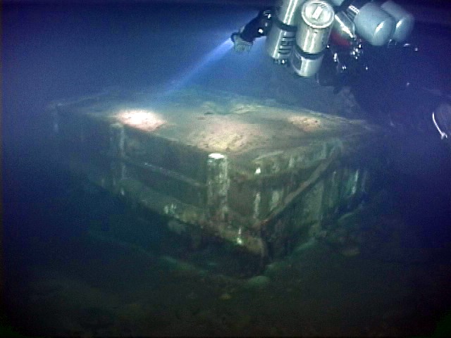
Diving on the Kyle Spangler
Diving on the John J. Audobon
Roubidoux Spring Map
The new extended Roubidoux Spring map is now available for $39.00 including first class shipping. Please include your shipping address when ordering. Be aware USPS has been moving mailing tubes rather slowly with 10-14 day delivery the new norm. This is out of our control.
Map size is 22″ x 42″
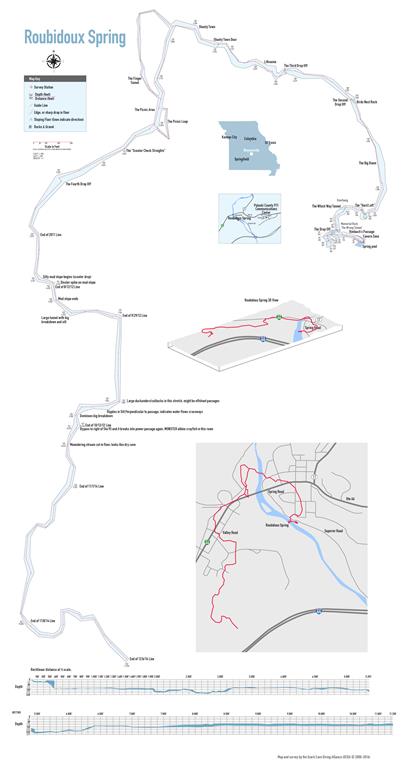
Roubidoux Info
Roubidoux Spring Maps
Welcome to the Roubidoux Spring information section. This is one of the few public springs available to cave divers in the state of Missouri. The City of Waynesville requires that all divers visit the Waynesville Emergency Center to check in before diving the spring. Be sure to check out after the dive! The Center is on top of the hill just north of city center.
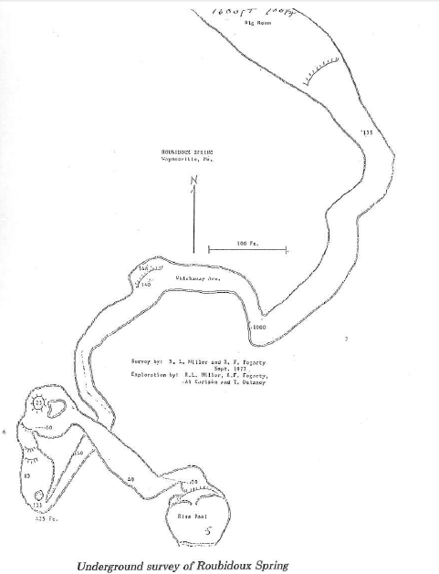
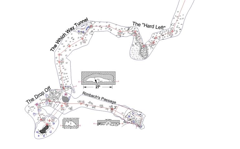
1977
1977 survey map from the legendary dive team of Miller & Fogarty
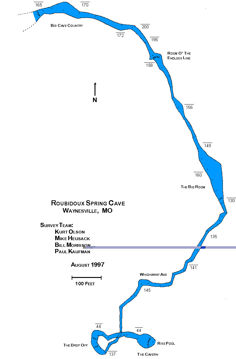
1997
1997 survey map from the dive team of Olsen, Husack, Morrison, andKaufman
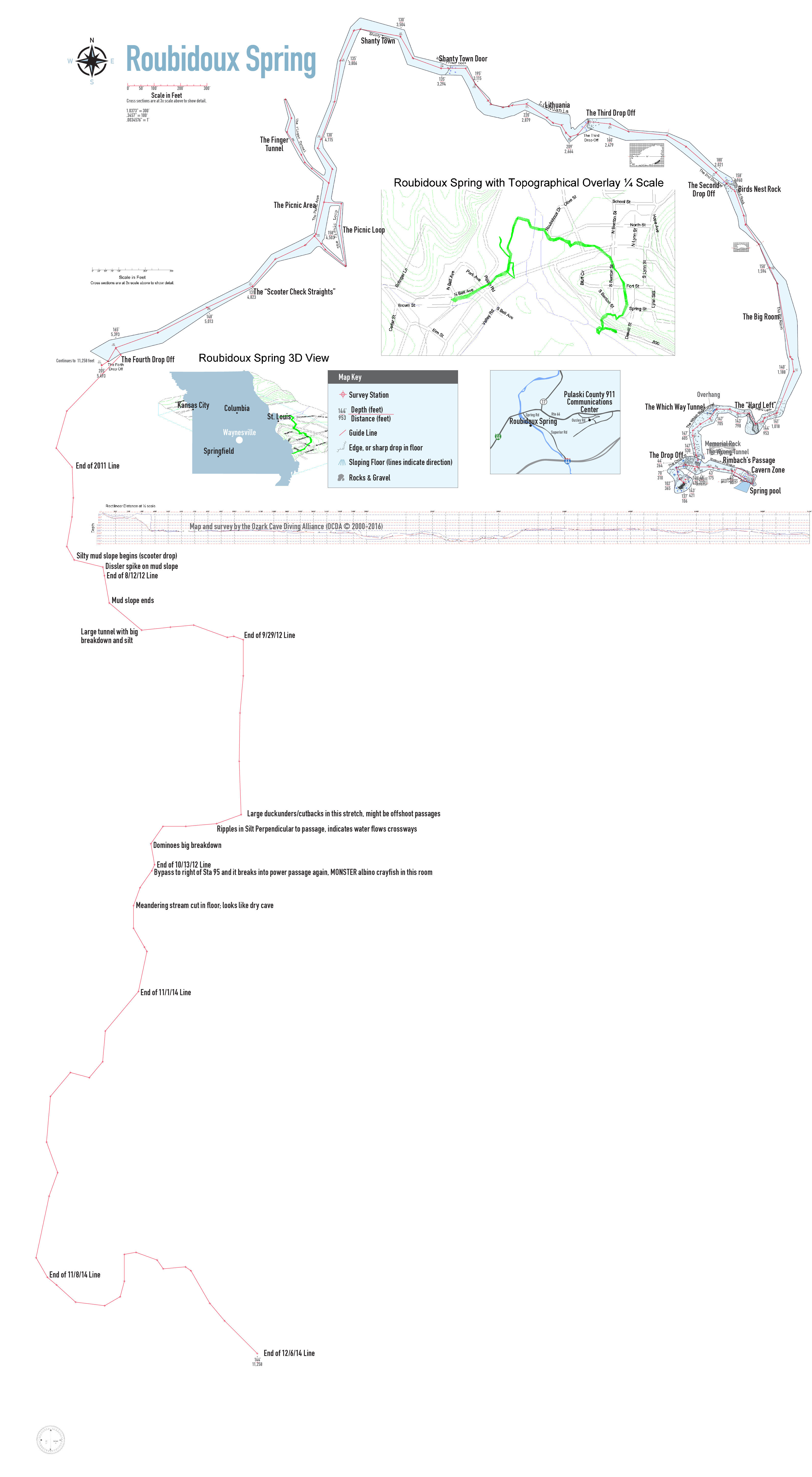
2018
2016 survey map from the OCDA out to 11,000’+
Home
Welcome to the home of the Ozark Cave Diving Alliance
Lewis Cave
On August 29, 2015 the dive crew of Ben Perkins, Bob Koch, Chris Hill, Konstantin Chartkov, Amanda Perkins, Diana Bentele, Vic Bentele, Alex Roberts, Dustin Ritter, Ken Grush, Stephanie Worrell, Zach Worrell, Brenda McMillen, and Trey McMillen acting as sherpas assembled at the entrance to Lewis cave at 7am. This trip was a follow up to a previous trip done by Ben and Dirk Bennett earlier in the month. Briefing and the route to the first sump (SP1) were uneventful, but laborious. We stopped about 100 feet before the start of SP1 to protect the water conditions and gear up. Divers divided in 2 buddy teams and the first team, which included the videographer, started the dive at about 10:20 am, second team followed in 5 min to allow for camera set up in DS2. This area greeted divers to a highly decorated section with a sandy bottom and banks of an underground stream passage. We transported our gear to a patch of dry area and took some time to look around and develop the strategy for trying to capture as much as we can on film. This was necessary because as soon as we started breathing, the room started filling with fog created by our breathing. This was expected as divers on the previous August 2nd expedition had encountered the same problem. At this point, anywhere we would look we saw cave formations. Ceiling was partially covered with white crystals that from the distance resembled layers of cotton. Speleothems hanging off the ceiling were predominantly white and were growing in all directions. When light was placed behind one of the bigger white stalactites, it would glow with a yellow light.
We enjoyed the view as much as we could until Bob notified us that he was done filming and we transported our cave diving gear across ~350’ of partially water filled passage and as before stopped well short of the opening of SP2. After a short break and preparing for our second dive of the day, I went in first. After a short but tight underwater passage we came out in a large room of Dry Section 3 (DS3). Moving as little as possible divers got out of the water so as not to destroy visibility for the following team. We placed our gear on a rocky bank and looked around. Although this was also a well decorated large room, the white crystals were not present. We waited for the other team and gave Bob the lead on moving forward with the camera while other 3 divers started surveying. After a short partially water filled crawl we ended up in yet another room and noted the sound of flowing water. To our right we noted a large break down that appeared “fresh” but after looking around we did not see the continuation of passage. To our left (where the sound of water was coming from) we saw a beautiful waterfall about 3 ft high. The passage above the waterfall continued but it looked low and rocks appeared “extra sharp” and would require an army crawl. To our right we noticed a dry passage which was leading up through yet another breakdown pile. We finished our survey for the day at the waterfall, and decided to take a peek at that passage. We finally were in the territory of “never seen before”.
When we squeezed through the breakdown it opened up into a parallel of the spring passage and terminated up a 25 ft clay hill with signs of surface water intrusion. One team moved up the waterfall passage and one along the newly discovered parallel passage. The waterfall passage was low with sharp rocks and parallel passage smoother but lower requiring belly crawling. The parallel tunnel had more open area to the one side but the vertical clearance was so low that it was impassable. Crawling forward the two passages connected and continued as one for ~100’. At that point the water was getting up within 4 inches of a very muddy ceiling making further progress impossible at this time. Further exploration will require a prolonged drought, or scuba gear, which would be very difficult to transport to the location. Furthest point of exploration is approximately 200 feet upstream of the waterfall.
After returning back to our gear at the inbound exit of Sump 2 we had been in the cave past the sumps for 6 hrs, and decided to head back to civilization. Cave exit was unremarkable, with a lot of help from the support crew. Support has exited previously and came back in to join up with us again. Everyone did a great job of keeping attitudes good despite it being the end of the day and everyone being tired. It was a great trip!
Note: Ben and Dirk’s first trip report into Lewis Cave on August 2nd can be found here.
Carroll Cave
On February 13, 2016 Laura Battle, Dirk Bennett, Bob Koch, David Moore, Tucker Palmatier, Ben Perkins, and the Carrol Cave Conservancy team of Bill Gee and Nathan Taylor, traveled downstream through Carroll Cave via Thunder River to check for an outlet in the Lake Room area. It was a long and strenuous day but very rewarding to see how large the Lake Room actually was. Tucker’s helmet mounted camera really shows what it was like getting there and can be viewed here. Project Manager Bill Gee wrote an excellent article on the trip here.
Privacy Policy
Who we are
Our website address is: https://www.ocda.org.
What personal data we collect and why we collect it
The Ozark Cave Diving Alliance does not collect or share any visitor information except for email addresses submitted for communication purposes.
Your contact information
If you contact us through the website for any reason your information will not be shared with anyone but the intended party or individual for communication purposes.
Media
If you upload images to the website, you should avoid uploading images with embedded location data (EXIF GPS) included. Visitors to the website can download and extract any location data from images on the website.
Embedded content from other websites
Articles on this site may include embedded content (e.g. videos, images, articles, etc.). Embedded content from other websites behaves in the exact same way as if the visitor has visited the other website.
These websites may collect data about you, use cookies, embed additional third-party tracking, and monitor your interaction with that embedded content, including tracing your interaction with the embedded content if you have an account and are logged in to that website.
How long we retain your data
Email addresses are held by the intended party until such time as they are no longer needed for communication purposes. If you leave a blog comment, the comment and its metadata are retained indefinitely. This is so we can recognize and approve any follow-up comments automatically instead of holding them in a moderation queue.
Links
For more information about Ozarks springs, caves, and other cave diving organizations, visit the following links.
Upstream Roubidoux Spring gauge
Missouri Caves & Karst Conservancy
Missouri Spring Flows
NSS-Cave Diving Section
Ozark National Scenic Riverways
Links by Joe Shaper
The Underwater Designer